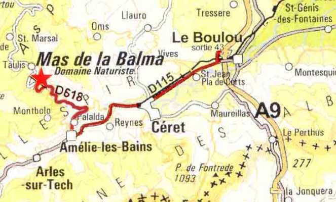
Itinerary for Mas de la Balma, 66110, France
- You leave the toll-road A9 at ‘Le Boulou’ (exit 43). Beware; this is the last exit in France, drive soonly on rightmost lane because the exit is before the row of toll booths you will see in front of you (you pass behind them and then get to your toll gates to exit).
- Then follow D115, direction Amélie-les-Bains, about 15 km.
- In Amélie-les-Bains on the second roundabout (ALDI supermarket on the left) follow direction Palalda and Montbolo.
- After passing the narrow bridge turn right, direction Palalda.
- You then follow the D618 in direction Taulis and Saint Marsal for about 10 km.
- You find Mas de la Balma about 2 kms before Taulis on your right hand side.
The entrance to the campsite along the D618 lies between the kilometersigns 58 and 57

ATTENTION!
-
Some navigatie-systems advise you directly after Céret to follow a different road, D15. This is a small and steep road.
-
Sometimes the navigation systems advise a different route at Amélie-les-Bains. That route follows the D53 to Montbolo. It is a steep road with a lot of hairpin curves. From Amélie-les-Bains you then have to climb 300 meters and then after passing the village you have to descend 200 meters to arrive at the D618
-
We advise our guests with caravans or campers not to follow these two routes.. You best follow D115 to Amélie-les-Bains and after that D618 direction Taulis and Saint Marsal.
GPS Coordinates:
(coordinates campisite entrance)
Latitude: 42,5121 N (= 42°30'43,6 N)
Longitude: 2,6325 E (= 2°37'57,0 E)
! some GPS systems don't have the right coordinates in the data base.


